
Urban Waters Federal Partnership - Edwards Aquifer Recharge Zone Monitoring Network Active
Contaminants in the Edwards aquifer
Where do they come from and how do they get there?
The USGS Texas Water Science Center is implementing a more complete and integrated monitoring network for the Edwards aquifer to improve the understanding of aquifer water quality and establish a baseline for measuring future water-quality changes.
Data from this study can be used to address these primary objectives:
- Long-term trends in water quality, with particular emphasis on nutrients and organic contaminants including pesticides, pharmaceuticals, and wastewater compounds.
- How surface water - groundwater interaction affects water quality changes over a range of hydrologic conditions.
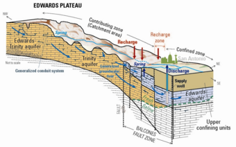
The San Antonio segment of the Edwards aquifer (hereafter, the Edwards aquifer), located in south-central Texas is a karst groundwater system that provides important water resources to the region, provides habitat for endemic and endangered species, and supplies major spring systems such as Comal Springs and San Marcos Springs.
In the face of increasing pressures from urbanization, a better understanding of the sources, fate, and transport of anthropogenic contaminants in the aquifer is needed to improve water management decision-making capabilities.
Additionally, the role of surface water-groundwater interaction, and effects on water quality under a range of flow conditions, is needed to understand urbanization impacts to the aquifer. Sources of anthropogenic constituents to the aquifer, such as nutrients, pesticides, pharmaceuticals, and other wastewater compounds and the influences of different land-cover types, are largely unknown.
Approach

An approach integrating real-time data logging, discrete sample collection, and automated sampling is being used to obtain water-quality data on major ions, nutrients, organic contaminants, and selected isotopes (hydrogen, oxygen, nitrogen, and strontium) in rainfall, recharging surface water, unconfined groundwater, confined groundwater, and spring discharge.
Continuous surface-water and groundwater measurements
Selected sites will include:
- Precipitation collection sites on the urbanized and rural portion of the Edwards aquifer recharge zone
- Surface water sites, selected to represent urban and rural surface-water runoff
- Groundwater sites with contrasting properties, including urban and rural settings and shallow unconfined and deeper confined groundwater wells
- Comal spring #1 –a major discharge point of the aquifer and integrator of regional aquifer flowpaths
Routine sampling
Routine samples have been collected at regular intervals through multiple years with the objective of covering a range of aquifer flow conditions.
Event-based sampling
Event-based samples have been collected in response to storm events from surface water sites, groundwater sites, and the spring discharge site. Additionally, precipitation samples have been collected and characterized for water quality.
More about other Urban Waters Federal Partnership projects
Below are other science projects associated with this project.

Urban Waters Federal Partnership Cooperative Matching Funds Projects

Urban Waters Federal Partnership - Edwards Aquifer Recharge in a Developing Landscape

Urban Waters Federal Partnership - Suspended Sediment and Nutrient Delivery to the Gulf of Mexico

Edwards Aquifer Recharge Zone Surface-water and Groundwater Interaction

National Water-Quality Assessment Project in Texas - Surface Water Activities

Edwards Aquifer Groundwater Model Uncertainty Analysis
- Overview
The USGS Texas Water Science Center is implementing a more complete and integrated monitoring network for the Edwards aquifer to improve the understanding of aquifer water quality and establish a baseline for measuring future water-quality changes.
Data from this study can be used to address these primary objectives:
- Long-term trends in water quality, with particular emphasis on nutrients and organic contaminants including pesticides, pharmaceuticals, and wastewater compounds.
- How surface water - groundwater interaction affects water quality changes over a range of hydrologic conditions.
Sources/Usage: Public Domain. View Media DetailsEdwards Aquifer conceptual model The San Antonio segment of the Edwards aquifer (hereafter, the Edwards aquifer), located in south-central Texas is a karst groundwater system that provides important water resources to the region, provides habitat for endemic and endangered species, and supplies major spring systems such as Comal Springs and San Marcos Springs.
In the face of increasing pressures from urbanization, a better understanding of the sources, fate, and transport of anthropogenic contaminants in the aquifer is needed to improve water management decision-making capabilities.
Additionally, the role of surface water-groundwater interaction, and effects on water quality under a range of flow conditions, is needed to understand urbanization impacts to the aquifer. Sources of anthropogenic constituents to the aquifer, such as nutrients, pesticides, pharmaceuticals, and other wastewater compounds and the influences of different land-cover types, are largely unknown.Approach
Sources/Usage: Public Domain. View Media DetailsSeco Creek sinkhole in Medina County provides direct recharge to the Edwards Aquifer. An approach integrating real-time data logging, discrete sample collection, and automated sampling is being used to obtain water-quality data on major ions, nutrients, organic contaminants, and selected isotopes (hydrogen, oxygen, nitrogen, and strontium) in rainfall, recharging surface water, unconfined groundwater, confined groundwater, and spring discharge.
Continuous surface-water and groundwater measurements
Selected sites will include:
- Precipitation collection sites on the urbanized and rural portion of the Edwards aquifer recharge zone
- Surface water sites, selected to represent urban and rural surface-water runoff
- Groundwater sites with contrasting properties, including urban and rural settings and shallow unconfined and deeper confined groundwater wells
- Comal spring #1 –a major discharge point of the aquifer and integrator of regional aquifer flowpaths
Routine sampling
Routine samples have been collected at regular intervals through multiple years with the objective of covering a range of aquifer flow conditions.
Event-based sampling
Event-based samples have been collected in response to storm events from surface water sites, groundwater sites, and the spring discharge site. Additionally, precipitation samples have been collected and characterized for water quality.
 Sources/Usage: Public Domain. View Media Details
More about other Urban Waters Federal Partnership projects
- Science
Below are other science projects associated with this project.
Urban Waters Federal Partnership Cooperative Matching Funds Projects
The Urban Waters Federal Partnership reconnects urban communities with their waterways by improving coordination among federal agencies, particularly those communities that have been disproportionately impacted by pollution or economic distress. The UWFP draws upon Environmental Justice principles—the idea that all people, regardless of race, religion, national origin, or economic station, deserve...Urban Waters Federal Partnership - Edwards Aquifer Recharge in a Developing Landscape
San Antonio Texas consistently ranks as one of the fastest growing large cities in the United States. Urban development can affect groundwater quality as trees and open space are replaced by buildings and roads, increasing the amount of urban runoff draining directly into the Edwards aquifer. A network of sophisticated surface water and groundwater monitoring sites is being used to help managers...Urban Waters Federal Partnership - Suspended Sediment and Nutrient Delivery to the Gulf of Mexico
Suspended sediment and nutrients from greater San Antonio can affect instream ecological health of the San Antonio River and ultimately impact Gulf of Mexico bays and estuaries. Real-time monitoring in urban and rural parts of the river basin may provide a glimpse into the importance of urban sediment and nutrient sources. Real-time sensors provide a tool to better understand and manage water...Edwards Aquifer Recharge Zone Surface-water and Groundwater Interaction
The effects of urbanization across the recharge zone in Bexar County and potential impact on the water quality in the Edwards aquifer is a topic of specific concern for the City of San Antonio. The USGS Texas Water Science Center is simultaneously collecting water-quality data from surface-water runoff sites and paired shallow groundwater wells within the recharge zone of the Edwards aquifer to...National Water-Quality Assessment Project in Texas - Surface Water Activities
The USGS National Water-Quality Assessment (NAWQA) Project was established by Congress in 1992 to answer the following question: What is the status of the Nation’s water quality and is it getting better or worse? Since 1992, NAWQA has been a primary source of nationally consistent data and information on the quality of the Nation’s streams and groundwater. Data and information obtained from...Edwards Aquifer Groundwater Model Uncertainty Analysis
USGS Texas Water Science Center (TXWSC) is undertaking a 1.5-year study to assess parameter and predictive uncertainty in the Edwards Aquifer Authority MODFLOW Model using both linear and non-linear techniques. The Edwards Aquifer Authority (EAA) uses two models simulating the periods from 2001 to 2015 (verification model) and the drought of record of 1947-1958 (drought of record model). - Publications
- Partners